Maps of Morocco
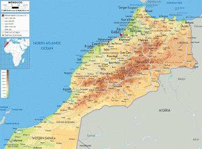
Physical Map
The first map below is a physical map. This physical map illustrates the physical features of Morocco such as mountains, rivers, and lakes. The different colors show representation of water and different elevation levels. Usually blue represents water, green represents lower elevation and orange or brown for higher elevation. this map also shows the surrounding areas of Morocco such as the Atlantic, Western Sahara and Algeria.
 |
| www.ezilon.com |
Political Map
The next map is a political map of Morocco. Political maps usually do not show physical features but instead indicate state, national boundaries, the capital city and other major cities. The capital city is represented by a start or square within a circle.
 |
| www.mapsofworld.com |
Economic Map
The map below is an economic map of Morocco and represents the types of natural resources and the economical activity that dominates a specific area. The symbols show the locations of the natural resources. In this economic Map it shows fuels, industry, winning and agriculture.
 |
| www.lib.utexas.edu |
No comments:
Post a Comment